I-70 AT ROUTE 201 INTERCHANGE PEL STUDY PUBLIC MEETING
ABOUT THIS SITE
Welcome to the Virtual Public Meeting for the I-70 at Route 201 Interchange Planning and Environment Linkages (PEL) Study. This virtual public meeting features station-by-station displays of study information. This material will be available until October 28, 2026 during the two-week comment period following the in-person public meeting on October 14.
Check out some of the Virtual Meeting Features:
Station Displays
Each of the available displays at the in-person stations is included below.
Comment Opportunity
A comment form is available following all of the virtual display information.
Station 1: Welcome and Introduction
Welcome!
Thank you for visiting the I-70 at Route 201 Interchange PEL Study Virtual Public Meeting Webpage, a product of the Pennsylvania Department of Transportation (PennDOT) Engineering District 12-0 and the Federal Highway Administration.
This virtual meeting will introduce the I-70 at Route 201 Interchange PEL Study.
View the video below to learn all about the study. Video captions are available - just click the CC/Subtitles button in the video player.
Station 2: PEL Study Overview / Transportation Process
What is a PEL?
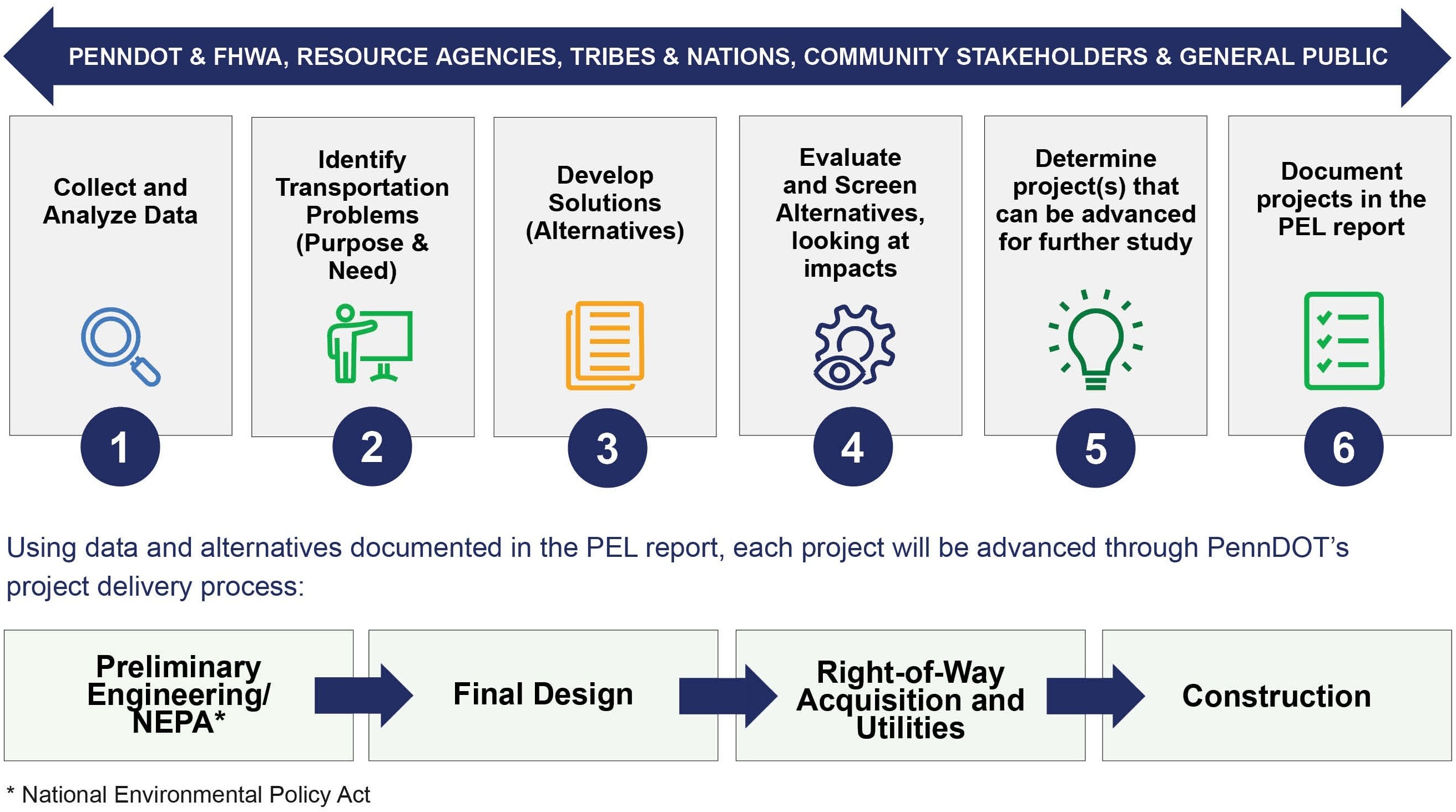
Planning and Environment Linkages (PEL) studies help to shorten project delivery time. They encourage the use of information developed in planning to inform the National Environmental Policy Act (NEPA) process. NEPA requires federal agencies to assess environmental effects before making final decisions on projects that use federal monies.
The PEL Study must involve interested State, local, Tribes and Nations, and federal agencies as well as the public, and document relevant decisions in a form that is identifiable and available for review during the NEPA scoping process.
Comprehensive Study
Combines planning, engineering & environmental studies
Provides Flexibility
In the early evaluation and dismissal of alternatives prior to detailed environmental & engineering studies
Minimizes Duplication
Uses decisions & analysis to inform future environmental studies
Encourages Engagement
Encourages early, meaningful public and agency engagement
Environmental Stewardship
Promotes environmental stewardship
Reduces Delays
Reduces delays in implementation
Study Area Map
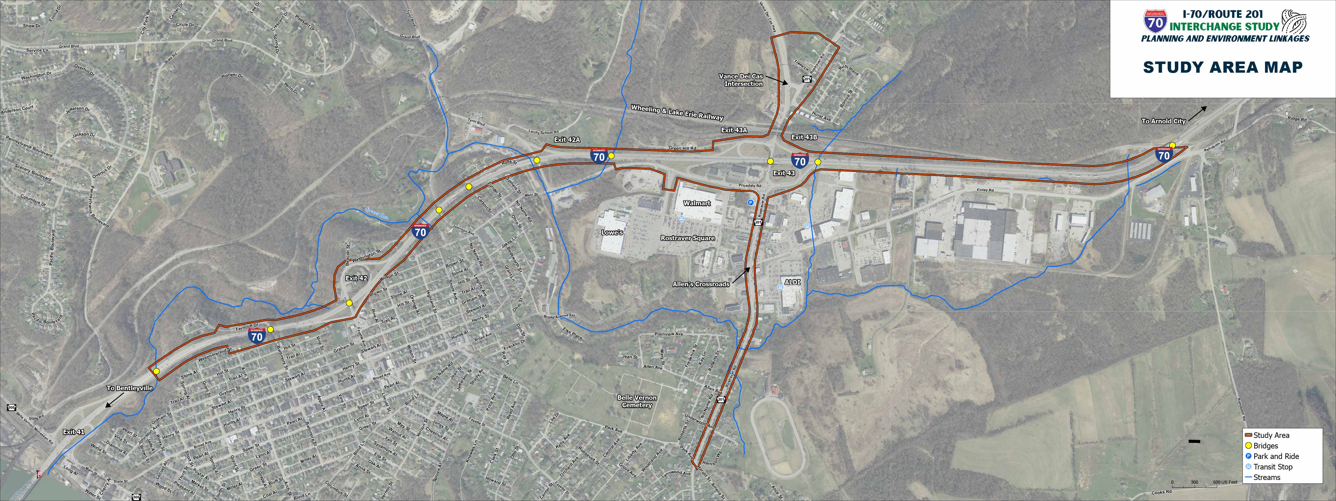
The study area includes the I-70/Route 201 Interchange, 2.8 miles of I-70 (Exit 41 to Exit 44), and 1.2 miles of Route 201 (Westmoreland/ Fayette County line to Vance Dei Cas Hwy). It is located in North Belle Vernon Borough and Rostraver Township, Westmoreland County.
This has been an area of concern for local officials for over 10 years. This study will consider solutions to reduce congestion, support pedestrian mobility, and increase safety at, and around, the I-70/Route 201 Interchange.
Click here to enlarge Study Area Map
Transportation Process
Planning & Environment Linkages (PEL) provides a stronger basis to determine Purpose and Need, community concerns, and local priorities for future project(s).
Station 3: Existing Roadway and Traffic Conditions
Existing/Projected Traffic Backups
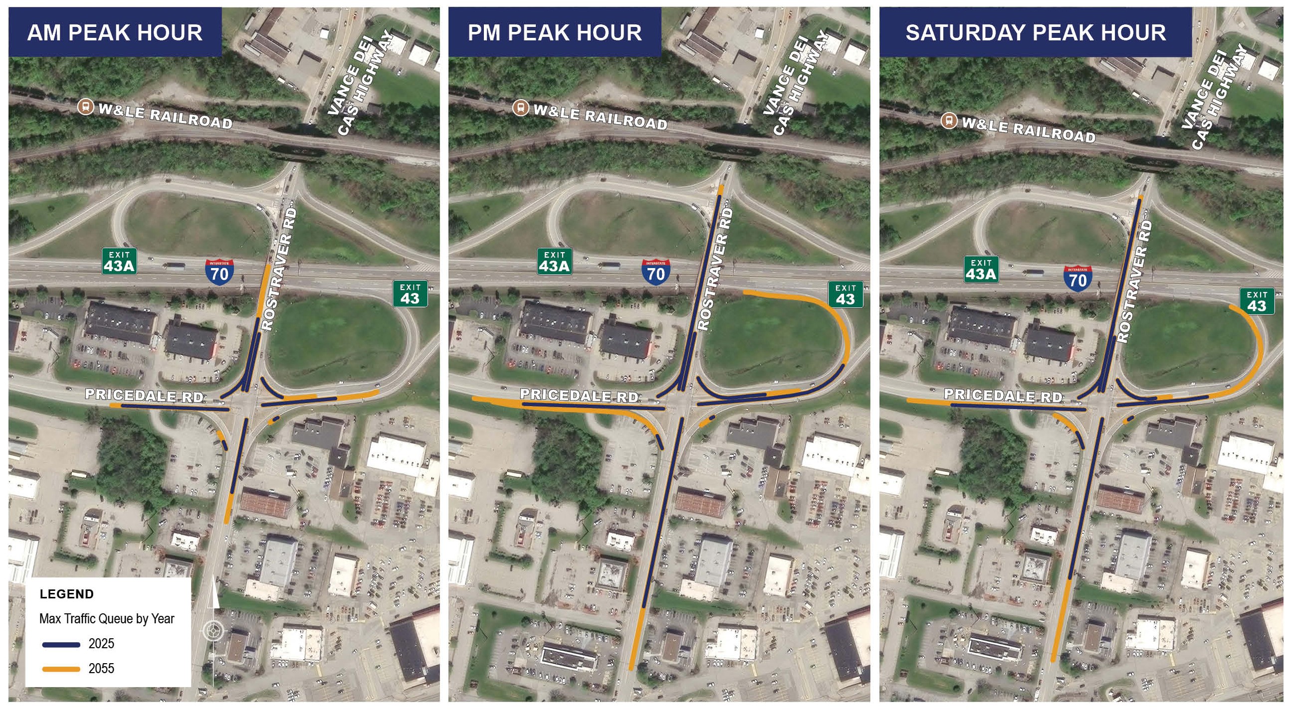
The map below illustrates the traffic backups during three peak times of the day in 2025 and compares those with the projected backups for 2055 at the intersection of Pricedale Road and Rostraver Road (Route 201).
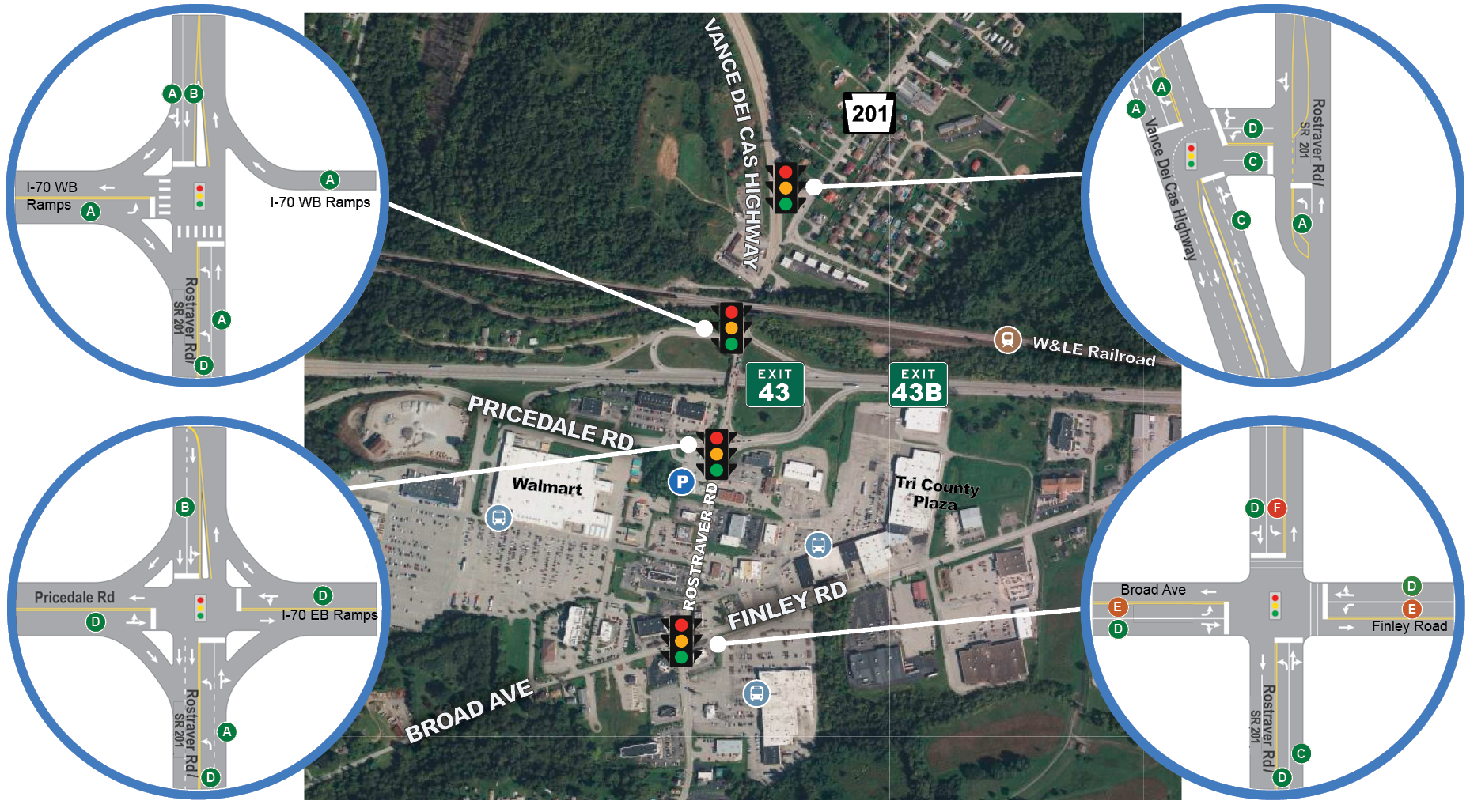
What is Levels of Service (LOS)?
LOS A - FREE FLOW
Low volumes and no delays.
LOS B - STABLE FLOW
Speeds restricted by travel conditions, minor delays.
LOS C - STABLE FLOW
Speeds and maneuverability closely controlled because of higher volumes.
LOS D - STABLE FLOW
Speeds considerably affected by change in operation conditions. High density traffic restricts maneuverability; volume near capacity.
LOS E - UNSTABLE FLOW
Low speeds; considerable delay; volume at or slightly over capacity.
LOS F - FORCED FLOW
Very low speeds; volumes exceed capacity; long delays with stop-and-go traffic.
Existing Conditions
(Based on 2025 counts during busiest traffic hours)
Click here to enlarge Existing Conditions
Projected Conditions (2055)
(Based on forecasted 2055 counts during busiest traffic hours, without improvements)
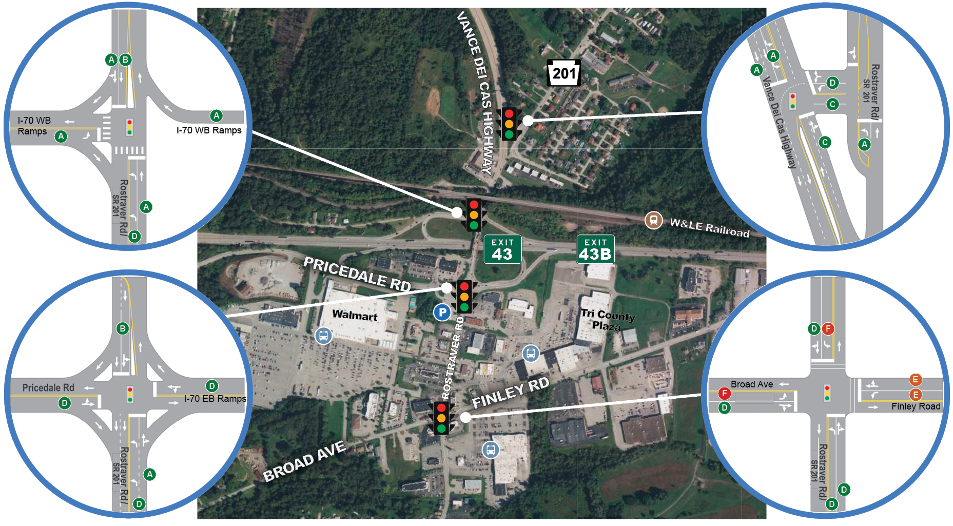
Click here to enlarge Projected Conditions
Roadway Issues
The study team identified various roadway issues within the study area.
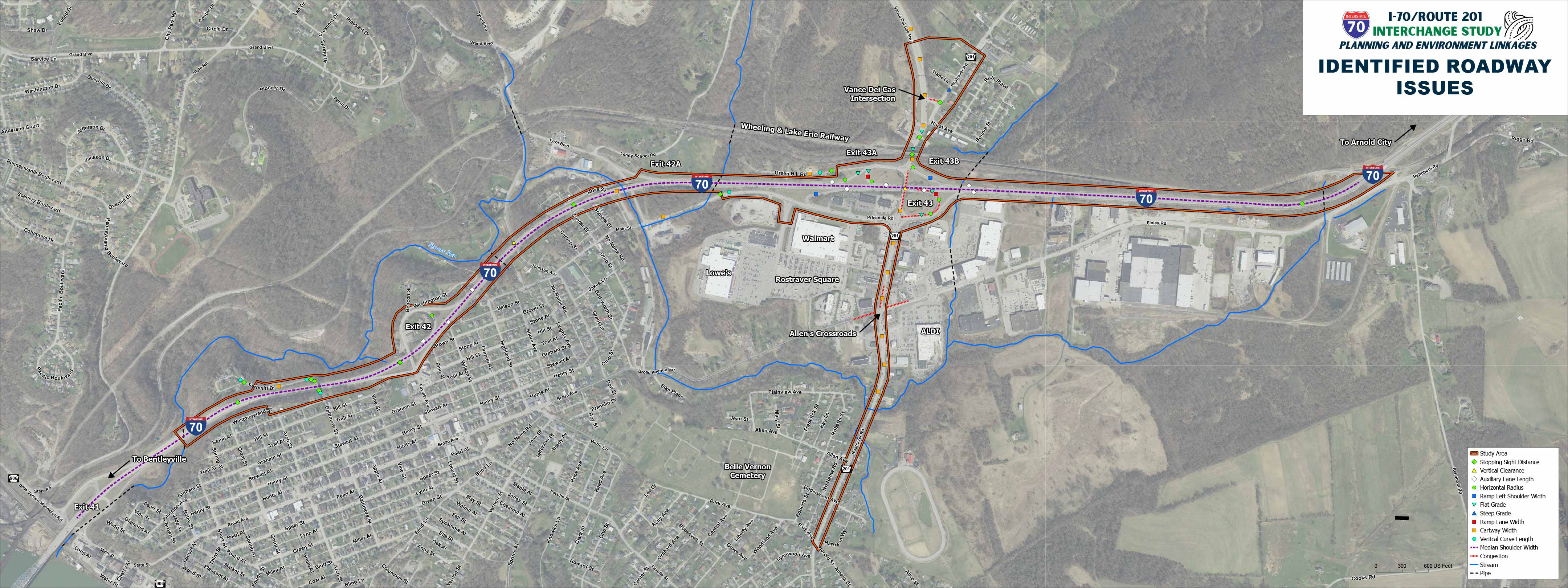
Click here to enlarge Roadway Issues
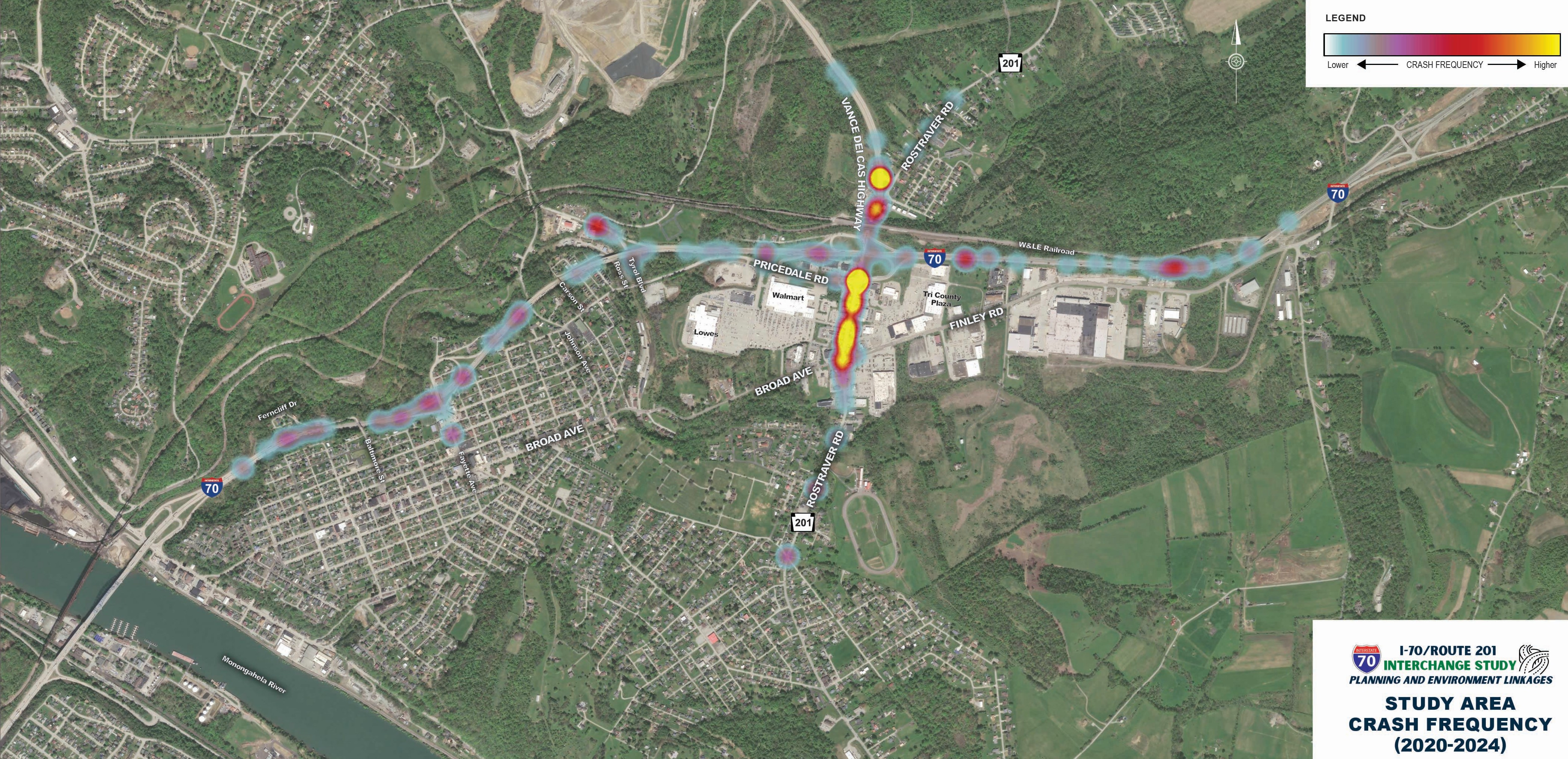
Crash Locations
The crash heat map shows the relative frequency of crashes in the 5-year analysis period. Route 201 south of the I-70 interchange is a hot spot for crashes. The complex geometry of the intersections at Vance Dei Cas and Route 201 may create driver confusion.
Station 4: Environmental Features
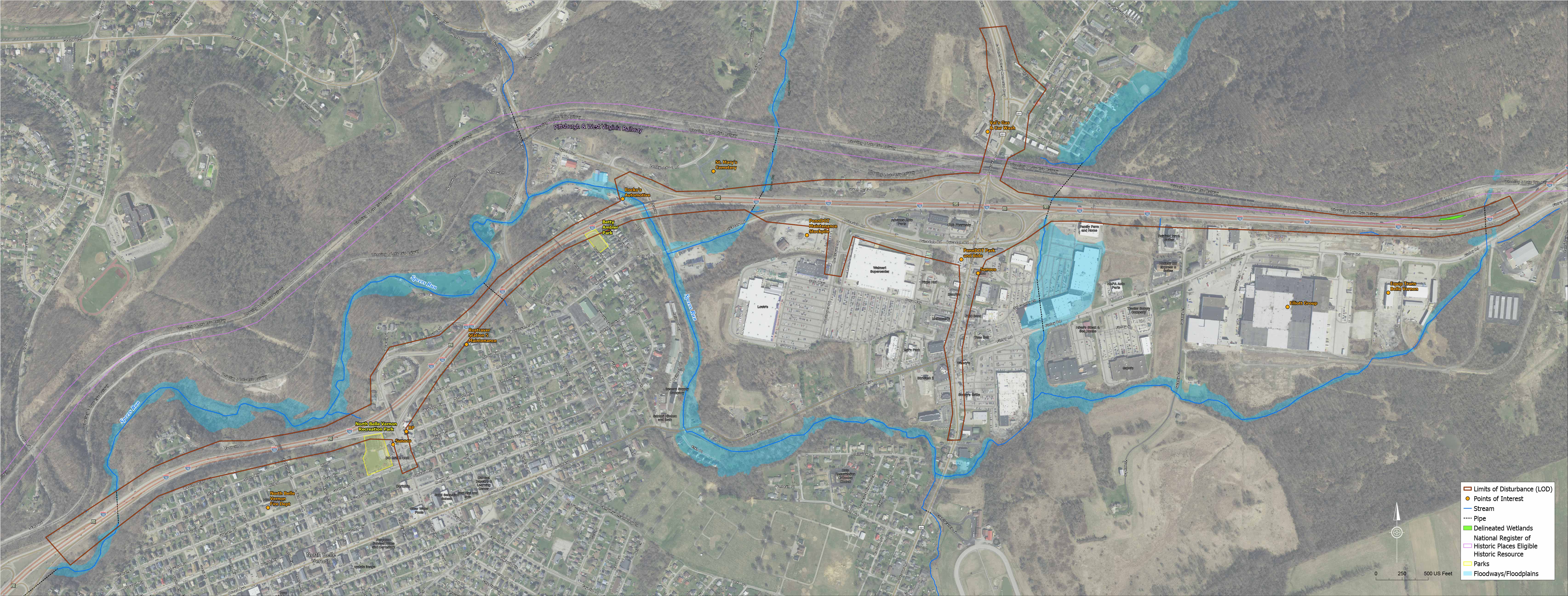
Environmental Features Map
Within the study area, environmental features are being mapped to provide groundwork for developing improvement concepts that would minimize natural, historic, social, and community impacts while meeting the purpose and need for the study.
The PEL study will collect and document baseline environmental information to support the evaluation and comparison of improvement concepts as the study progresses. The environmental studies will include wetland and stream assessments, identification of cultural and historic resources, noise considerations, identification of parks and community features, mapping of threatened and endangered species, and other environmental resources and constraints that may influence the development and evaluation of improvement concepts.
Ultimately, PennDOT will look for ways to avoid, minimize, and mitigate impacts to environmental features.
Station 5: Draft Purpose and Need
Draft Purpose
The purpose of this study is to develop and evaluate alternatives to address roadway and bridge deficiencies of I-70 (from Exit 41 (Route 906) to the bridge carrying I-70 over the W&LE Railroad) while maintaining and/or improving the connectivity of local roadways and pedestrian access.
The study will also evaluate improvement options along Route 201 to address the safety and mobility needs (for multiple modes of transportation) of that corridor within the study area.
Draft Need
Roadway Deficiencies
Existing roadway configurations contributing to safety concerns within the study area.
Structure Deficiencies
Existing deficiencies associated with a few bridges that contribute to safety concerns in the study area.
Congestion
High peak hour traffic volumes cause congestion and result in unacceptable Levels of Service (LOS D or E) on the Route 201 roadway and intersections within the study area.
Safety
Based on analysis of crashes within the study area, the roadways in the study area perform worse than similar roadways from a safety perspective.
Modal Interrelationships
The lack of sidewalks and/or ADA compliant crosswalks along Route 201 create safety issues and poor transit stop connections.
System Linkage and Mobility
I-70 within the study area is not consistent with District 12’s I-70 modernization typical section widths. This is considered a secondary need in the study area.
Station 6: Community Stakeholder Committee & Comment Opportunity
Community Stakeholder Committee
A Community Stakeholder Committee will be convened to provide input and feedback to the Study Team and share information and updates with their respective community segments. Committee members will be assigned by the Study Team to ensure that all areas of interest are represented.
State Elected Officials
County/Local Government
Emergency Services
Education
Transit
Local Business & Industry
Community Facilities
Residents
Community members interested in being considered to represent any of the following community stakeholder segments may submit an interest form at this public meeting or by mail before October 28, 2026.
Stay in Touch!
Cristin Covert, P.E.
PennDOT District 12
Project Manager
Phone: 724-439-7155
Email: ccovert@pa.gov
Ty Murcko, P.E.
McCormick Taylor
Project Manager
Phone: 412-923-3935
Email: tmurcko@mccormicktaylor.com